Google Earth
16 Strangest Sights You Can Spot on Google Earth
Google Earth is a fantastic program that creates 3D images of the world via highly sophisticated satellites hovering above the Earth. It enables anyone to search for a location on Earth, from a city in the United States to the snow-capped mountains of New Zealand, and discover what it looks like in real life.
The program also uses aerial photos from airplanes and drones to map out the world’s geography, with Google revealing more than 97% of the world has been captured along with more than 10 million miles of Street View imagery. With so much of the Earth photographed randomly over the years, some extraordinary images have been captured. We want to dive into the strangest sights on Google Earth that might surprise you.
Images range from natural creations to man-made structures and mysterious buildings and islands that nobody quite knows much about. As these images prove, the Earth is a very different place when viewed from above.
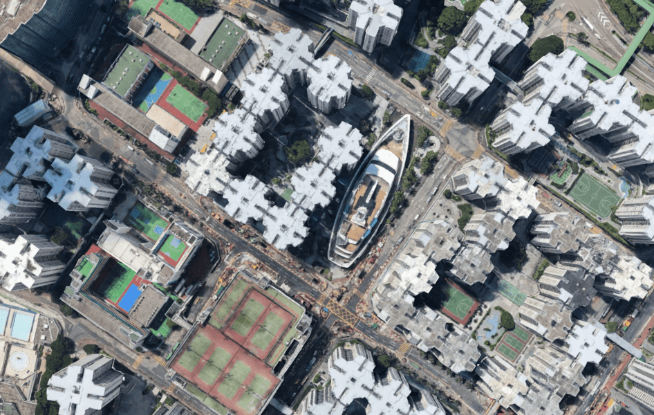
1. Cruise Ship Shopping Center
Imagine walking through the streets of Hong Kong and stumbling upon this. In Whompoa Garden, a private housing estate in Hong Kong, there is a mini-cruise ship in the middle of the city. It has been converted into a shopping mall that features theaters, department stores, restaurants, and even a small theme park.
Whompoa used to be a thriving dock until it was destroyed during World War II and rebuilt as a housing estate for the wealthy. The ship sits in a large pool of water that was once part of the docks and is visited by millions every year.
2. An Island in a Lake, on an Island, in a Lake, on an Island

This naturally occurring phenomenon blew people’s minds when it was first discovered. As you can see, it’s an island-in-a-lake-on-an-island-in-a-lake-on-an-island. Confused yet?
The image shows a tiny island residing inside a crater on an island known as Volcano Island in a lake called Taal lake. It might be a little hard to warp your head around, but it’s a very unique discovery that only something like Google Earth could find.
3. Phantom Island

Located off the east coast of Australia, Sandy Island is a non-existent island that has been the center of controversy for centuries. Captain James Cook first took note of the island in 1776, and this was confirmed by several more expeditions over the years. But in 1974 the French Naval and Oceanographic Service removed Sandy Island from its maps.
Then in 2012, an Australian expedition was undertaken to map the island properly, but when the team got to its location they found nothing but water. Turns out the island doesn’t exist after all. It was quickly taken off of Google Maps and Google Earth, although you can still see the faint outline of where the island was thought to be.
4. Firefox Crop Circles

Google Earth
Although it no longer exists, when this crop circle appeared in 2006 it had people wondering if aliens were responsible for Firefox. Turns out it was actually a bunch of students from Oregon State University who created the crop circle to celebrate the web browser’s 50 millionth download. Still impressive nonetheless, with Google Earth users getting a kick out of the design when it first appeared.
5. Beijing South Railway Station

This might not look overly strange to some of you, but using Google Earth certainly offers a different perspective of China’s Beijing South Railway Station. It’s one of Beijing’s major transport hubs and services much of the country.
6. Atlantis

You can’t really see much with this image at first glance, but look closely and you will see a grid-like formation that looks like streets. Early explorers believed this was the ruins of the fabled city of Atlantis. Located off the coast of Africa, the area is believed to be the size of Wales and got many treasure hunters and archeologists excited at the prospect of finally finding the lost city.
Google Earth broke their hearts when they revealed the grid formation was actually caused by the sonar boats collecting data to create the images used in the mapping process. Although not the news people wanted to hear, there are still some who believe Atlantis is located nearby.
7. Strange Signs

This image features strange signs and symbols found at several American and British Army bases around the world. This particular shot shows a base in Norwich, England, with the U.K. Ministry of Defense calling it a motorcycle range, whatever that means.
The most logical explanation is that it’s got something to do with satellite positioning, but there are many who think these squiggly lines are messages to our alien brethren in space.
8. Aircraft Graveyard

Located in Arizona, Davis-Monthan Air Force Base is home to over 4,400 aircraft. First established as a landing field in 1925, it’s now the place where aircraft come to die. The majority of planes found there are ex-Airforce, with the dry and arid climate of Arizona perfect for preserving these aircraft.
See more about - 20 Hilarious Cursed Images That Will Creep You Out
9. Man-Made Paradise

The United Arab Emirates is one of the wealthiest countries in the world and features some of the most expensive and outlandish hotels ever created. Many of these luxurious accommodations can be found on several man-made islands as the one above. These impressive creations shoot out into the ocean and have everything from theme parks to sandy beaches and massive hotels.
10. Swastika Building

Google Earth
In 2007, Google Earth found this controversial swastika shaped building complex in San Diego. The four unconnected buildings are part of the Coronado Naval Amphibious Base built in 1967. Obviously, it’s not something the U.S. Navy wants to be associated with and they have spent more than $600,000 trying to hide the design, but nothing escapes Google Earth.
11. Desert Breath

The Desert Breath installation is an Egyptian artwork located near the Red Sea. The mastermind of the D.A.ST. Arteam collective, consisting of three Greek artists – sculptor Danae Stratou, industrial designer, Alexandra Stratou, and architect Stella Konstantinidis, architect – the Desert Breath is 89 dirt cones of varying sizes that will slowly erode over time.
12. Lisakovsk Pentagram
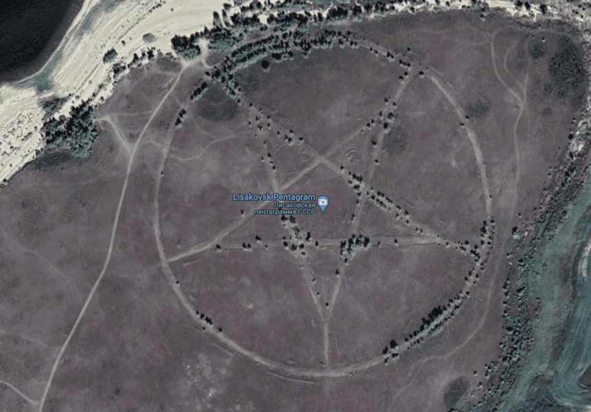
Google Earth
Nobody was quite sure when or why this Pentagram appeared on Google Earth back in 2013. Located in northern Kazakhstan, many thought it might be the portal to Hell, but they were sadly mistaken. After some research, it was found to be an uncompleted Russian summer camp designed in the shape of a star.
“It is the outline of a park made in the form of a star,” archaeologist Emma Usmanova told NBC’s LiveScience, putting to bed any rumors of Devil worship.
13. Badlands Guardian

Resembling an indigenous American with a headdress, the Badlands Guardian was first discovered in 2005 by Lynn Hickox. While it looks like it has been carved into the Earth, the image is all natural and a freak natural occurrence.
The Badlands’ Guardian is located near Medicine Hat in the southeast of Alberta, Canada, which is home to the Siska First Nation People.
14. Desert Cruise

This image might not seem that strange, as it is just a car driving through the Moroccan desert, but you might notice the top of the car. It seems to have two body-shaped bags tied to the roof. Now we aren’t saying they are bodies, but we aren’t saying they are not either. A very mysterious image.
15. Blood Lake

Google Earth
The crimson-colored Blood Lake in Iraq came to the attention of Google Earth users in 2007. While there is no official word for why the lake is red, one rumor that did the rounds was that a local abattoir flushed the blood from dead animals into the lake, turning it red. The more plausible explanation is that there is some type of algae in the lake or it’s from waste thrown into the lake.
16. Sidecar

Google Earth
This image captured by Google Earth comes from the Netherlands and features a car turned on its side. There is no rhyme or reason for why this car is on its side, but it provides one of the strangest sights on Google Earth.
See more about - 12 Things You Should Never Google